

Evidence of the Flood in Fanklin County
by Gerald Durr
TABLE OF CONTENTSI. INTRODUCTION
II. EVIDENCES OF A FLOOD
A. COULEES
B. GRAVEL BARS
C. DEVIL'S CANYON
D. PALOUSE FALLS
E. RINGOLD BASIN
F. ERRATICS
G. THE UPLAND FLATS
III. THE GEOLOGISTS EXPLAIN
A. THE BRETZ FLOODS
B. LAKE MISSOULA
C. BASALT ROCK FEATURES
D. FLOOD VELOCITIES
E. OVERFLOW CHANNELS
IV. EVALUATION OF THE FLOOD THEORY
A. THE FLATLANDS QUESTION
B. LAKE LEWIS
V. CONCLUSIONS
I. INTRODUCTION
"Enthusiasts bill it as the greatest
story left untold. It is the story of the earth's power, scientific
discovery, and human nature. This is the tale of how the Northwest was once
changed by geologic catastrophe on a biblical scale."1
These words are the introduction to the
KSPS Public Television program titled, "Sculpted by Floods: the Northwest's
Ice Age Legacy," narrated by investigative reporter Alison Kartevold. Her
documentary report tells the story of the Ice Age Floods, Washington's
Channeled Scablands, and the geologists who sought to discover their
origins.
"The region is unique," wrote geologist
J. Harlen Bretz. "Let the observer take the wings of the morning to the
uttermost parts of the earth; he will find nowhere its likeness."2
In this report, we will look at just a
part of this flood-damaged region. We will focus on the visible evidence of
a flood in Franklin County, in the Columbia Basin Region of Eastern
Washington.
II. EVIDENCES OF A FLOOD
As I travel from place to place in
Franklin County, I often marvel at the variety of geological features I see:
deep canyons and coulees, gravel mounds, a beautiful waterfall, basalt rock
outcroppings, river valleys, and flat, fertile farmlands. These interesting
and sometimes unusual features have raised questions in my mind. I like to
ask, "How did that rock get there?" or, "What kind of force made that valley
with such steep sides?" These questions have led me to investigate the
geology of Franklin County.
In this report, I would like to
describe some of the unusual features found in Franklin County, look at the
currently accepted theory of their origins, and then briefly evaluate that
geological theory in light of the evidence available.
My interest in the local geology was
first aroused when traveling in the area around Connell, Washington. I lived
in Connell for five years, so I became very familiar with the landscape in
that area. Thus we will begin our study in Connell.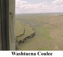
The Coulees. Whether
approaching Connell from the north, south, east, or west, it is necessary to
descend a long slope. All of the surrounding land is at 1000 to 1100 feet
elevation,3
but Connell lies in the bottom of a gully at 850 to 900 feet. This gully is
the intersection of three coulees - Providence Coulee to the north,
Washtucna Coulee to the east, and Esquatzel Coulee to the south.4
Providence Coulee is deep and narrow, with V-shaped, hilly sides. Washtucna
Coulee is deep and about a mile wide, with grassy rangeland at the bottom
and steeply sloping, somewhat rounded basalt cliffs at the sides. Esquatzel
Coulee is very deep, with bare basalt cliffs at the sides.
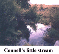 Providence Coulee has a small stream at the bottom. It flows through the
middle of Connell, enters Esquatzel Coulee to the south, and continues on
until it reaches Pasco. This small stream is a home for cattails and frogs.
Farther down the coulee, it provides water for grazing cattle. Just before
reaching Pasco, the water is drawn off into the
Providence Coulee has a small stream at the bottom. It flows through the
middle of Connell, enters Esquatzel Coulee to the south, and continues on
until it reaches Pasco. This small stream is a home for cattails and frogs.
Farther down the coulee, it provides water for grazing cattle. Just before
reaching Pasco, the water is drawn off into the
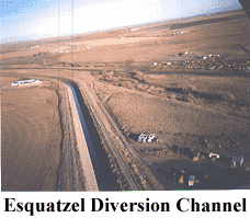 Esquatzel
Diversion Channel and carried to the Columbia River. The coulee itself loses
its impressive basalt walls when it reaches Eltopia, then becomes just a
small gully until the land around it flattens out into a plain just north of
the Pasco Airport.
Esquatzel
Diversion Channel and carried to the Columbia River. The coulee itself loses
its impressive basalt walls when it reaches Eltopia, then becomes just a
small gully until the land around it flattens out into a plain just north of
the Pasco Airport.
Highway 260 runs along the southern lip
of Washtucna Coulee on its way to Kahlotus. This widest of the three coulees
doesn't have a stream running in it, but it does have two lakes that are
gradually drying out, called
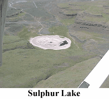 Sulphur
Lake and Lake Kahlotus. Lake Kahlotus is 865 feet above sea level. I've
spoken to residents of Kahlotus who said that Lake Kahlotus has shrunk in
the past 30 years. It once was a good fishing spot, but now it hardly has
enough water for a fish to live in. At first I asked, "Where did all the
water go?" But then, upon further thought, I had to ask, "Where did the
water come from in the first place?" There is no apparent stream or other
source.
Sulphur
Lake and Lake Kahlotus. Lake Kahlotus is 865 feet above sea level. I've
spoken to residents of Kahlotus who said that Lake Kahlotus has shrunk in
the past 30 years. It once was a good fishing spot, but now it hardly has
enough water for a fish to live in. At first I asked, "Where did all the
water go?" But then, upon further thought, I had to ask, "Where did the
water come from in the first place?" There is no apparent stream or other
source.
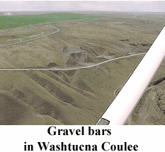
Gravel Bars. Also found in
Washtucna Coulee are several very large gravel bars.5 Some of
these have ripple marks along their tops. How did that gravel get there?
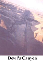 Devil's Canyon. Just south of Kahlotus, Highway 263 enters Devil's
Canyon. This is a steep-sided, V-shaped canyon that descends 400 feet in
four miles. Its sides are made of basalt rock, with much talus, or broken
rock, covering the slopes. Devil's Canyon ends at the Snake River. The Snake
River above Lower Monumental Dam has an elevation of 540 feet.
Devil's Canyon. Just south of Kahlotus, Highway 263 enters Devil's
Canyon. This is a steep-sided, V-shaped canyon that descends 400 feet in
four miles. Its sides are made of basalt rock, with much talus, or broken
rock, covering the slopes. Devil's Canyon ends at the Snake River. The Snake
River above Lower Monumental Dam has an elevation of 540 feet.
As I drove down the canyon one day, I
wondered if it could have been made by running water. The problem is, there
was no apparent source of water. From Kahlotus, elevation 865 feet, the road
climbs to 1000 feet before descending into Devil's Canyon. That means that
the canyon has a barrier at its upper end. How could the water rise 135 feet
in order to enter the canyon?
You may have noticed that we just moved
from a coulee to a canyon. Actually, both words mean the same thing. When
the French-Canadian fur traders were exploring the Columbia Basin, they
noticed that there were many dry gullies with steep sides. They called these
gullies "coulees," and the French name became commonly used in Eastern
Washington. "Canyon," on the other hand, is a Spanish word meaning "a narrow
chasm with steep cliff walls, formed by running water; a gorge."6
This word became a familiar word in the English language because of the many
canyons in our nation's Southwest, where Spanish missionaries and Mexican
settlers named the geographic features.
Although "canyon" and "coulee" mean
almost the same thing, there are some very noticeable differences between
Devil's Canyon and Washtucna Coulee. Devil's Canyon is V-shaped, and the
canyon floor descends rapidly (roughly 100 feet per mile). Washtucna Coulee
is box-shaped, with vertical sides and flat bottom. It descends only about
200 feet in 32 miles (roughly 6 feet per mile).
Let's continue heading northeastward
from Kahlotus up Washtucna Coulee. Eventually we would reach Washtucna, at
the upper end of the coulee. There the elevation is 1014 feet. But Washtucna
is about a mile north of the Franklin County border, so we won't discuss it
in this report. I would, however, like to describe another fascinating
geological feature near that town.
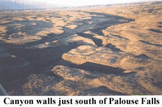
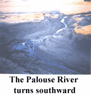 Palouse Falls. If we were to turn east onto Highway 26 at Washtucna, we
would soon be driving alongside the Palouse River. The Palouse River flows
out of Idaho, passes through the towns of Palouse and Colfax, and meanders
through the Palouse Hills. It forms a part of the border between Whitman and
Adams Counties. Then, about 3½ miles east of Washtucna, at the very eastern
border of Franklin County, this lazy, meandering river makes a sharp turn
southward and flows in a straight line over rapids and falls for four miles.
Palouse Falls. If we were to turn east onto Highway 26 at Washtucna, we
would soon be driving alongside the Palouse River. The Palouse River flows
out of Idaho, passes through the towns of Palouse and Colfax, and meanders
through the Palouse Hills. It forms a part of the border between Whitman and
Adams Counties. Then, about 3½ miles east of Washtucna, at the very eastern
border of Franklin County, this lazy, meandering river makes a sharp turn
southward and flows in a straight line over rapids and falls for four miles.
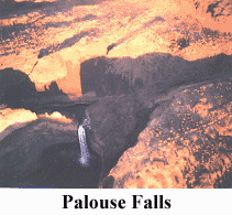 Then
it makes a 185-foot plunge over Palouse Falls.7 Here the basalt
walls are vertical cliffs. You can clearly see the various layers of basalt,
with their colonnades and entablatures.
Then
it makes a 185-foot plunge over Palouse Falls.7 Here the basalt
walls are vertical cliffs. You can clearly see the various layers of basalt,
with their colonnades and entablatures.
When I see a sudden change in the
earth's features, I like to ask why. Why did a lazy, meandering river
suddenly become a rushing rapids flowing as straight as a stick for four
miles? And what made that river suddenly fall 185 feet, then again meander
calmly down to the Snake River?
The basalt cliffs near Palouse Falls
have a curious tendency to make sharp, 90° turns.8
There is a deep canyon that cuts a perpendicular line across the river gorge
just south of the falls.9 What geologic force has cut those
canyons so straight and at such remarkable angles?

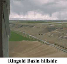 Ringold Basin. About 18 miles to the southwest of Connell is the town of
Basin City. Basin City is located in Ringold Basin - a U-shaped depression
with steep slopes on both sides. These steep hillsides are over 100 feet
high and covered with desert vegetation. In places the hillside is breaking
off and sliding away. The slopes begin about 5 miles south of Othello and
run southward past Basin City to Ringold and the Columbia River, a distance
of about 15 miles. The slopes make me think of a dike alongside a river. But
the only water in sight is a small stream.
Ringold Basin. About 18 miles to the southwest of Connell is the town of
Basin City. Basin City is located in Ringold Basin - a U-shaped depression
with steep slopes on both sides. These steep hillsides are over 100 feet
high and covered with desert vegetation. In places the hillside is breaking
off and sliding away. The slopes begin about 5 miles south of Othello and
run southward past Basin City to Ringold and the Columbia River, a distance
of about 15 miles. The slopes make me think of a dike alongside a river. But
the only water in sight is a small stream.
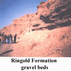 The Erratics. Basin City is built on gravel beds. Local farmers
sometimes find huge boulders in their fields - not just the basalt rock that
we would expect in this area, but granite and metamorphic rock as well.
These unusual rocks must have come from far away in the mountains.
Geologists can trace them to their source in the Okanogan Highlands or even
the Rocky Mountains. Since these rocks are out of place here in the Pasco
Basin, they are called erratics. How did such large boulders move here from
so far away?
The Erratics. Basin City is built on gravel beds. Local farmers
sometimes find huge boulders in their fields - not just the basalt rock that
we would expect in this area, but granite and metamorphic rock as well.
These unusual rocks must have come from far away in the mountains.
Geologists can trace them to their source in the Okanogan Highlands or even
the Rocky Mountains. Since these rocks are out of place here in the Pasco
Basin, they are called erratics. How did such large boulders move here from
so far away?
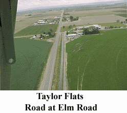
The Upland Flats. Now let's look
at some rather unremarkable features in Franklin County. It took me years to
notice them, because they seem so ordinary. These are the upland "flats." We
will begin in Pasco and travel northward.
When you turn north off of I-82 onto
Road 68, the road is straight and level for 2½ miles.
 Where
the road forks at Douglas Fruits, you veer off to the right onto Taylor
Flats Road. For 2½ more miles, the road winds back and forth, passing
through some undisturbed sagebrush and undulating, wavy hills. For the next
4 miles, the road goes gently up and down, crossing hills and gullies and
slowly rising in elevation. Between Sagemoor Road and Cypress Drive, the
road climbs steeply.
Where
the road forks at Douglas Fruits, you veer off to the right onto Taylor
Flats Road. For 2½ more miles, the road winds back and forth, passing
through some undisturbed sagebrush and undulating, wavy hills. For the next
4 miles, the road goes gently up and down, crossing hills and gullies and
slowly rising in elevation. Between Sagemoor Road and Cypress Drive, the
road climbs steeply.
Finally, at the top of the hill, the
land flattens out. At night I can see headlights appear two miles away and
know that a car has just passed Elm Road. The road is flat and straight for
those two miles, not varying more than 20 feet in elevation. But beyond the
small hump at Elm Road, the "flats" go on for another four miles, until
Taylor Flats Road ends at Eltopia-Ringold Road. These upland flats are not
the Taylor Flats, which are found alongside the Columbia River, but I call
them the "flats" because of their similarity to the Paradise Flats between
Connell and Othello.
You may be asking, "What is so unusual
about a flat area?" At first I saw nothing unusual about this area, until I
began to see others like it. The Taylor Flats plateau has an elevation of
almost exactly 900 feet. When you drive on Highway 395 northeastward toward
Mesa, you will see that Mesa is at the bottom of Esquatzel Coulee. Its
elevation is 675 feet. But up above Mesa are steep hillsides. If you look
around the horizon, you will see that the land above Mesa flattens out into
a plateau. Its elevation is 930 feet.
Continuing farther to the northeast on
Highway 395, we come again to Connell. The road to Connell is lined with
basalt outcroppings and deep gullies.
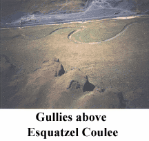 If
you look through the gullies toward the west, you can see that they empty
into the Esquatzel Coulee. The far walls of the coulee are visible from the
road in some places, but the floor of the coulee is far below and out of
sight. (The walls are roughly 200 feet high.) It seems that these gullies
must be washouts, draining the water from the nearby fields into the Coulee.
But there is no water in sight. The gullies are dry. This is an example of
channeled scablands.
If
you look through the gullies toward the west, you can see that they empty
into the Esquatzel Coulee. The far walls of the coulee are visible from the
road in some places, but the floor of the coulee is far below and out of
sight. (The walls are roughly 200 feet high.) It seems that these gullies
must be washouts, draining the water from the nearby fields into the Coulee.
But there is no water in sight. The gullies are dry. This is an example of
channeled scablands.
As you approach Connell, you can
actually see the town from several miles away. There is a flat spot on
Highway 395, and it lines up with Esquatzel Coulee so that you can see
Connell down in its gully.
I have noticed an unusual feature in
the topography of Connell - there are two "shelves." Above the floor of the
coulee, there is a hill, and then a shelf. Connell High School sits on this
shelf. Its elevation is 900 feet - the same elevation as the "flats" above
Pasco. Then there is another hillside above the high school, so steep that
nothing is built or grown on it. Above this upper hillside, the land
flattens out, and once again, the horizon looks flat. This area is at
approximately 1000-1100 feet and is called Paradise Flats.10
It seems that the land levels out above
Connell on each side. Across Esquatzel Coulee to the west, the land looks to
be the same elevation as Paradise Flats to the north. Across Washtucna
Coulee to the northeast, it seems to be flat and on the same level as
Paradise Flats. There seems to be a pattern here - and again I must ask,
"Why?"
III. THE GEOLOGISTS EXPLAIN
Let's look at what the geologists say. "In a sense, geologists are much like detectives: Although they were not present when an event occurred, they must collect and piece together physical evidence and must fit this evidence into a logical and 'most likely' scenario of what occurred at the scene. They must then convince their peers that their theory is the most believable one among several possibly conflicting theories."11
The Bretz Floods. A geologist named J. Harlen Bretz explored the dry coulees of Eastern Washington beginning in 1919. As he wondered at the geological marvels of Dry Falls, Grand Coulee, and the Potholes, it seemed to him that these features had to have been made by enormous volumes of water flowing across the land in the distant past.12 Although at first he didn't know where the water could have come from, he published a scientific paper in which he proposed his theory of widespread flooding in the Columbia Basin. Other geologists did not immediately accept his theory, but Bretz continued his explorations throughout the next several decades, gradually accumulating enough data to convince the scientific community that his theory was accurate.
Lake Missoula. It remained for other geologists to find the source of the waters that caused the flooding and devastation in the Columbia Basin. The current theory is that a lobe of glacial ice blocked the flow of the Clark Fork River in western Montana about 12,000 years ago. The dammed-up river then filled all of the valleys behind it to a depth of 2,000 feet.13 This vast reservoir of water, named Lake Missoula by the geology "detectives," then suddenly broke through the ice dam and emptied out within a matter of days. Such a tremendous release of water had a devastating effect downstream on the landscape of Idaho and Eastern Washington. It scoured away the topsoil and then carved deep channels into the bedrock. The deluge eventually drained away down the Columbia River to the Pacific Ocean. Geologist Bretz coined the term "channeled scablands" to describe this flood-scoured landscape.
Basalt Rock Features. And how did the water cut through solid rock? Much of Eastern Washington is underlain by extensive basalt flows - volcanic lava that spilled out of fissures of the earth in the distant past and flowed like syrup to fill the Columbia Basin. When basalt lava cools, it hardens and cracks into a column-shaped rock. The many cracks form a natural weakness in the rock structure. When rapidly moving water flows in abundance over these rocks, the water actually separates the rocks at their weakest points and lifts them into its stream. When the loosened rocks are propelled in the current, they can become a battering ram capable of smashing other rocks apart.
Flood Velocities. The Ice Age
Floods are estimated to have had velocities in some places of as much as 75
feet per second (50 miles per hour). "If the velocity of a stream is
doubled, its ability to move material along the bottom increases up to 64
times."14 Geologists estimate that the glacial floodwaters
reached a height of 1000 feet above the rock surface in some places. This
volume and velocity of water could move huge boulders for hundreds of miles.
Geologists believe that the waters of
Lake Missoula divided into several channels. One of these channels flowed
southward from Cheney toward Pasco, crossing over Palouse Falls and
eventually reaching the Snake River. They believe that Washtucna Coulee was
once the channel of the Palouse River, flowing from east to west. But when
the glacial floods flowed southward across the area, they cut a new channel
for the Palouse River, a shortcut to the Snake River. This forever altered
the course of the Palouse. That's why the Palouse River turns suddenly
southward near Washtucna and flows over Palouse Falls on its way to the
Snake River.
A smaller channel of the glacial floods flowed south-southwest through
Providence Coulee. There it met the Palouse River at Connell and flowed down
Esquatzel Coulee to Pasco.
Overflow Channels. During the
height of the flood, Washtucna Coulee was filled to overflowing. There was
so much water that it spilled over the top at Kahlotus and ran rapidly down
the slope to the Snake River, forming Devil's Canyon. This overflow,
however, didn't cut all the way through the rock at the side of Washtucna
Coulee, so the entrance to Devil's Canyon is still approximately 135 feet
above the floor of the coulee.
A much larger flow of glacial waters made its way south past Othello,
scooped out the Ringold Basin, and joined the waters of the Columbia. It
left huge gravel deposits at Basin City and the Ringold area.
IV. EVALUATION OF THE FLOOD THEORY
 The evidence of a flood is irrefutable. Dry coulees, huge gravel bars, giant
ripple marks, and erratic boulders all point to enormous volumes of water
flowing at great speeds. But I have a few unanswered questions that beg for
an answer. The main question I will deal with in this report is "What
created the flatlands?"
The evidence of a flood is irrefutable. Dry coulees, huge gravel bars, giant
ripple marks, and erratic boulders all point to enormous volumes of water
flowing at great speeds. But I have a few unanswered questions that beg for
an answer. The main question I will deal with in this report is "What
created the flatlands?"
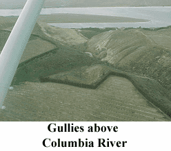
The Flatlands Question. The coulees were formed by the raging floodwaters of Lake Missoula. The floods washed out Ringold Basin. Many gullies visible above the Columbia River were formed by water drainage off the plateau farmlands. There's a pattern here - running water causes gullies and depressions.
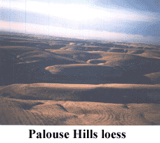
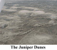 Geologists say that the Palouse Hills to the east of Franklin County are
rolling hills made of "loess." Loess is wind-blown silt. The Juniper Dunes
northeast of Pasco are sand dunes, caused by the gradual movement of
wind-blown sand.15 There's a pattern here, too - when the
landscape is dominated by wind-blown materials, it is hilly.
Geologists say that the Palouse Hills to the east of Franklin County are
rolling hills made of "loess." Loess is wind-blown silt. The Juniper Dunes
northeast of Pasco are sand dunes, caused by the gradual movement of
wind-blown sand.15 There's a pattern here, too - when the
landscape is dominated by wind-blown materials, it is hilly.
But what causes flatlands? Is it
reasonable to assume that they were "caused" by a geological force, just as
the hills and the gullies were caused by known forces?
Although I haven't found any
explanation written by a geologist, I think I can guess what causes
flatlands. It appears to me that the upper flatlands have some of the best,
most fertile soil. It seems that moving air or water doesn't flatten the
land, but tends to "rough up" the land. The silty soil that is so common in
the Pasco area is easily moved by running water. Ripple marks, whether on
the beach or in the gravels of Washtucna Coulee, are made by running water.
Therefore, I would guess that the flatlands were formed by sediments
settling out of calm waters.
Immediately, my hypothesis raises a big
question. There are flatlands at 900 feet elevation just 14 miles north of
Pasco. Across Ringold Basin, about 20 miles north of Pasco, there are
flatlands on the Wahluke Slope, also at 900 feet elevation. Above Mesa there
are flatlands at 930 feet elevation. Above Connell, 35 miles northeast of
Pasco, there are flatlands at 1000 to 1100 feet elevation. All of these
areas are separated by coulees and basins said to be cut out by the Missoula
Floods. If this is true, then all of the areas I've mentioned must have been
connected before the floods. That's a huge amount of real estate, very flat,
gently sloping from north to south, and all at 900 to 1100 feet of
elevation. Could there have been a body of water big enough to cover that
extensive area? The geologists say yes.
Lake Lewis. About 12 miles
south of Pasco, the Columbia River flows through a narrow gap in the Horse
Heaven Hills. This opening is called Wallula Gap. The geologists say that
during the Ice Age Floods, the floodwaters reached the Horse Heaven Hills
and began to back up behind Wallula Gap, because the water couldn't drain
through the gap quickly enough. They say that a temporary lake, called Lake
Lewis, was formed as the waters backed up and then drained through the
constriction. Lake Lewis was supposed to have risen up to 1250 feet
elevation at the peak of the floods, and then drained out within a week or
two.16
That sounds like a lot of moving water.
On the beach, when a gently flowing stream or a wave washes across the sand,
it leaves ripples. There are no ripples on the upland "flats" I've
mentioned. How could the waters of the Ice Age Floods have overflowed these
flat areas and left them still flat? It seems to me that a vast, high, calm
lake must have made the "flats".
I attended a geology lecture and field
at Columbia Basin College in Pasco, Washington. The lecturer, a geologist at
Battelle Pacific Northwest National Laboratories in Richland, Washington,
made some interesting comments. After explaining a geologist's
interpretation of the Columbia Basin's natural features, he asked the
students, "Do you believe that?" I think he was inviting us to question the
geological detective work. He also told us at the end of the lecture, "In
ten years, they'll teach all of this different." When a geologist "reads the
rocks" and "pieces together the evidence," he or she forms a hypothesis to
explain the evidence. Sometimes the pieces don't all fit together. Sometimes
there are questions left unanswered.
V. CONCLUSIONS
Everyone who studies science
approaches it with some preconceived notions. Geologist J. Harlen Bretz was
severely criticized and rejected by his colleagues when he postulated a
cataclysmic flood.17
The idea of "Catastrophism" had been thrown out and ridiculed in the 100
years since James Hutton first proposed his theory of Uniformitarianism.
Before Hutton, the general consensus in the Western Hemisphere was that the
Bible was true and fully reliable. But Hutton challenged the authority of
the Bible and tried to make people doubt its credibility. It took over a
hundred years, but with the help of many like-minded intellectuals over the
next century, Hutton's theory gained acceptance.
So the geologists of Bretz' day were
shocked and offended to hear that their colleague had the audacity to
believe that a vast flood had rapidly changed the face of the earth. It was
unthinkable! It was unacceptable! Their predecessors had worked hard to root
out the common people's belief in a worldwide flood. By the early 1900's,
most geologists had rejected the idea of a biblical flood. They weren't
prepared to tolerate a new flood theory.
I wonder why those scientists were so
upset. Isn't "science" a search for truth? If new evidence of a flood came
to light, why were they so adamant that it couldn't be possible? It seems
that they weren't as interested in a search for truth as in defending what
they believed.
This report began with a
thought-provoking quotation from the video production "Sculpted by Floods:
The Northwest's Ice Age Legacy." It said, "This is the tale of how the
Northwest was once changed by geologic catastrophe on a biblical scale." I
like that thought. But let's keep the record straight: the tale of the
Missoula Floods isn't on a biblical scale. When the Bible speaks of a great
flood, it says this:"The same day were all the fountains of the great
deep broken up, and the windows of heaven were opened. And the rain was upon
the earth forty days and forty nights….And the waters prevailed, and were
increased greatly upon the earth; and the ark went upon the face of the
waters. And the waters prevailed exceedingly upon the earth; and all the
high hills, that were under the whole heaven, were covered. Fifteen cubits
upward did the waters prevail; and the mountains were covered."
(Genesis 7:11-12, 18-20) In the biblical account, the floodwaters
covered the whole earth, including all the hills and mountains. Is it
possible that Lake Missoula could have been a remnant of a flood that once
covered the whole earth?
I invite you to consider the
possibility that the Bible may be true. We have no eyewitnesses and no
written records of the Ice Age Floods. But we do have a written record of a
worldwide flood. Before researching the Missoula Floods, I had looked at the
geologic features of Franklin County and hypothesized that a great lake had
once covered this area - a calm lake. I thought that perhaps the lake
existed before Wallula Gap was carved out. Perhaps the biblical floodwaters
remained in the Columbia Basin until the pressure of such a vast lake could
carve through a weak spot in the Horse Heaven Hills. This way, the waters
would drain off slowly, leaving flat, undisturbed plateaus of fertile, silty
soils. Now, even after studying about the Ice Age Floods theory, I think
that my hypothesis fits the observable facts. I admit that I have a bias -
some preconceived notions. Doesn't everyone? What you think? Your
preconceived notions will determine what you believe and how you live.
ENDNOTES
1). Kartevold, video.
2). Nisbet, p. 29.
3). All elevation figures in this report provided by the U. S. Geological
Survey maps via Microsoft TerraServer.
4). Washington Atlas and Gazetteer, p.54.
5). Mueller, pp. 89-91.
6). American Heritage Dictionary of the English Language, p.198.
7). CREHST, p.11.
8). See Mueller, cover photo, 1997 printing.
9). Allen, p.68.
10). Washington Atlas and Gazetteer, p. 54.
11). Mueller, p. 21.
12). Allen, p. 21.
13). Mueller, p. 27.
14). Allen, p. 97-98.
15). Carson, pp. 26-28.
16). CREHST, p. 2.
17). Allen, pp. 42-44.
BIBLIOGRAPHY
Allen, John E., Marjorie Burns, and Sam C. Sargent, 1986. Cataclysms on the Columbia: A layman's guide to the features produced by the catastrophic Bretz floods in the Pacific Northwest. Portland, Oregon: Timber Press.
AmericanHeritage Dictionary of the English Language, 1969. Boston, Mass.: Houghton Mifflin Company.
Carson, Robert J., and Kevin R. Pogue, 1996. Flood Basalts and Glacier Floods: Roadside Geology of Parts of Walla Walla, Franklin, and Columbia Counties, Washington. Washington Division of Geology and Earth Resources Information Circular 90: Washington State Dept. of Natural Resources.
Columbia River Exhibition of History, Science, and Technology, 2001. "Geologic Field Trip: Ice Age Floods in the Mid-Columbia."
Kartevold, Alison, 2001. "Sculpted by Floods: The Northwest's Ice Age Legacy." Spokane, Washington: KSPS Public Television.
Mueller, Marge, and Ted, Mueller, 1997. Fire, Faults, and Floods. Moscow, Idaho: Univ. of Idaho Press.
Nisbet, Jack, 1999. Singing Grass, Burning Sage: Discovering Washington's Shrub-Steppe. Seattle, Wash.: The Nature Conservancy of Washington.
U. S. Geological Survey topographic maps online. Microsoft TerraServer.
Washington Atlas and Gazetteer, 1995. Freeport, Maine: DeLorme.